

Velokarten Schweiz Kümmerly+Frey
Switzerland, Neuchâtel - Trois Lacs - Seeland - Fribourg, Nr. 08, Velokarte 1:60 000

Article Number: 978-3-259-02408-9
Scale: 1:60 000
This product is in stock.
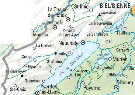
In the Kümmerly+Frey cycle map Neuchâtel - Three Lakes at a scale of 1:60 000 you will find everything you need for orientation and inspiration.
The map shows the most important areas of interest from Biel, Saint-Imier, Neuchâtel, Murten, Yverdon-les-Bains to Fribourg.
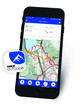
Thanks to the clearly marked, up-to-date and easy-to-read cantonal and national cycle routes (Veloland Schweiz) and mountain bike trails, the uncluttered map image, the clear terrain display and the option to download the map via the HKF Outdoor app, the map is the perfect tool for making the most of your visit to this exceptional region. Thanks to the noted ascents and descents as well as warnings for difficult passages, you are optimally prepared for your self-created route.
The noted bicycle-friendly accommodations also help you to put together tours of several days yourself. The marked chairlift, cable car or boat loading stations can also be useful.
The map contains detailed topographic information such as contour lines and elevation data for mountain peaks, passes and larger lakes, thus providing a precise picture of the terrain. This gives cyclists a particularly realistic impression of the landscape.
The folding map for cyclists is made of a robust, largely water-resistant and tear-proof paper. It will not let you down even in difficult weather conditions.
Should the GPS not work or the mobile phone run out of battery, the cycling routes clearly marked on the map with distance information in kilometres and route number, viewpoints, stations, picnic areas, refreshment stops, etc. will always help you to keep your bearings.
About Hallwag Kümmerly+Frey
We, Hallwag Kümmerly+Frey, have set ourselves the goal of inspiring people to explore the world. Our road maps, city maps, hiking maps, cycling maps, etc. impress with their up-to-dateness, accurate cartography, well-researched routes and clear layout, so that the planning and the journey itself are a success.
Start your adventure well prepared with us!
Cycling in Switzerland The popular Kümmerly+Frey ATE cycling maps convey all the important information cyclists want before and during a trip: gradients, altitude differences, road surfaces, and traffic volume... Cantonal and national cycling paths (Cycling in Switzerland) and mountain bike courses are specifically marked. All maps feature useful additional information: places of interest accommodation and restaurants. With index and a regional approach map. Water- and rip-proof map.Scale: 1:60 000
Free shipping in Switzerland*
20% discount for 3 items
* Except for bulky good deliveries (posters)
Digital maps
PLAN, DISCOVER, EXPERIENCE - on the web and mobile!
Download our HKF Outdoor App!
Navigator
More than 1000 Web-Sites in 47 countries! Listing of important European Web-Sites supporting your planning and booking of journeys.