


Wanderkarten Schweiz Kümmerly+Frey
Switzerland, Lake Lucerne, No. 11, Hiking map 1:60'000

Article Number: 978-3-259-02211-5
Scale: 1:60 000
This product is in stock.
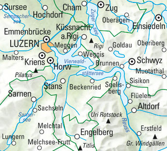
In the Kümmerly+Frey hiking map of Lake Lucerne, Engelberg - Lucerne - Schwyz at a scale of 1:60 000 you will find everything you need for orientation and inspiration.
The map shows the most important areas of interest from Sursee, Lucerne, Küssnacht a. Rigi, Brunnen, Schwyz, Altdorf, Sarnen, Melchsee-Frutt, Engelberg, Einsiedeln, etc..
Thanks to the clearly marked, easy-to-read and up-to-date hiking trails, the uncluttered map image, the clear terrain display and the possibility to download the map via HKF Outdoor App, the map is the perfect tool to make the most of your visit to this exceptional region.
The map includes detailed topographic information such as 25m contour lines and elevations of mountain peaks, passes and major lakes, giving an accurate representation of the terrain. This gives hikers a particularly realistic impression of the landscape.
The folding map for hikers is made of a robust, largely water-resistant and tear-proof paper. It will not let you down even in difficult weather conditions.
Should your GPS not work or your mobile phone run out of battery, the clearly marked hiking trails, viewpoints, railway stations, refreshment stops, campsites, car parks, etc. on the map will help you to keep your bearings.
As a supplement to Hiking Map No. 11, we recommend the maps of the neighbouring regions:
- Switzerland, Aargau, Fricktal - Hallwilersee, No. 05, Hiking Map 1:60'000
- Switzerland, Zurich, No. 06, Hiking Map 1:60,000
- Switzerland, Emmental, Napf - Entlebuch, No. 10, Hiking Map 1:60,000
- Switzerland, Glarnerland, Muotatal - Klausenpass, No. 12, Hiking Map 1:60,000
- Switzerland, Gotthard, Grimsel - Susten - Oberalp, No. 19, Hiking Map 1:60,000
About Hallwag Kümmerly+Frey
We, Hallwag Kümmerly+Frey, have set ourselves the goal of inspiring people to explore the world. Our street maps, city maps, hiking maps, cycling maps, etc. impress with their up-to-dateness, accurate cartography, well-researched routes and clear layout, so that the planning and the journey itself are a success.
Start your adventure well prepared with us!

Your benefit
Free shipping within Switzerland for 2 or more items*
* Excludes bulky items (posters)
No shipping to the USA
Due to current customs regulations, shipping to the USA is unfortunately not possible at the moment for cost reasons.
Thank you for your understanding.
Not found the right product?
Browse our extensive range – you’re sure to find the perfect one.