


Wanderkarten Schweiz Kümmerly+Frey
Switzerland, Jungfrau Region, No. 18, Hiking Map 1:60'000

Article Number: 978-3-259-02218-4
Scale: 1:60 000
This product is in stock.
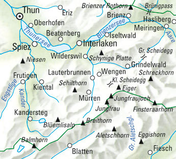
In the Kümmerly+Frey Hiking Map Jungfrau Region, Thuner- and Brienzersee, scale 1:60,000, you will find everything you need for orientation and inspiration.
The map covers the most important areas of interest, including Thun, Spiez, Interlaken, Brienz, Hasliberg, Brünigpass, Schynige Platte, Kleine Scheidegg, Grindelwald, Fiesch Balmhorn, and Frutigen.
Thanks to clearly marked, easy-to-read, and up-to-date hiking trails, a clean map design, a clear representation of the terrain, and the option to download the map via the HKF Outdoor App, this map is the perfect tool to make the most of your visit to this exceptional region.
The map includes detailed topographic information such as 25m contour lines and elevations of mountain peaks, passes, and larger lakes, providing a precise depiction of the terrain. Hikers, therefore, gain a particularly realistic impression of the landscape.
The folding map for hikers is made of sturdy, largely water-resistant, and tear-resistant paper. Even in challenging weather conditions, it won't let you down.
In case the GPS doesn't work or your phone runs out of battery, the clearly marked hiking trails, viewpoints, train stations, places to rest, camping sites, parking lots, etc. on the map will always help you maintain your orientation.
As a complement to Outdoor Map No. 18, we recommend the maps of neighboring regions:
- Switzerland, Bern, No. 09, Hiking Map 1:60,000
- Switzerland, Emmental, Napf - Entlebuch, No. 10, Hiking Map 1:60,000
- Switzerland, Simmental - Saanenland, No. 17, Hiking Map 1:60,000
- Switzerland, Gotthard, Grimsel - Susten - Oberalp, No. 19, Hiking Map 1:60,000
- Switzerland, Aletsch - Goms, No. 25, Hiking Map 1:60,000
- Switzerland, Crans-Montana, No. 32, Hiking Map 1:60,000
About Hallwag Kümmerly+Frey:
We, Hallwag Kümmerly+Frey, have set ourselves the goal of inspiring people to explore the world. Our road maps, city maps, hiking maps, bicycle maps, etc. impress with their up-to-date information, precise cartography, well-researched routes, and clear layout, making planning and the journey itself a success. Start your adventure well-prepared with us!

Your benefit
Free shipping within Switzerland for 2 or more items*
* Excludes bulky items (posters)
No shipping to the USA
Due to current customs regulations, shipping to the USA is unfortunately not possible at the moment for cost reasons.
Thank you for your understanding.
Not found the right product?
Browse our extensive range – you’re sure to find the perfect one.