

Outdoorkarten International Kümmerly+Frey
Croatia, Istria, Outdoor Map 1:75'000

Article Number: 978-3-259-00749-5
Scale: 1:75 000
This product is in stock.
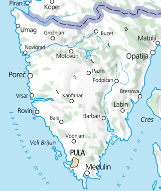
In the Kümmerly+Frey Istria Outdoor Map, Pula - Opatija - Rovinj, at a scale of 1:75,000, you will find the best routes for a variety of sports.
The map covers areas of interest including Umag, Porec, Rovinj, Pula, Medulin, Cres, Labin, Opatija, Pazin, Matulji, and more, highlighting trails and leisure opportunities.
Thanks to clearly marked, easily readable, and up-to-date paths, as well as the clean map design and the option to download the map via the HKF Outdoor App, this map is the perfect tool to make the most of your visit to this extraordinary region.
The map contains all necessary information for indulging in outdoor activities in your area. Not only are cycling and hiking paths clearly presented, but also details about golf, tennis courts, via ferratas, indoor pools, museums, playgrounds, bowling alleys, and more, aiding you in optimizing your leisure time.
The foldable map for outdoor enthusiasts is made of robust, largely water-resistant, and tear-resistant paper. It won't fail you even in challenging weather conditions.
Should your GPS not work or your phone run out of battery, the clearly marked viewpoints, train stations, dining options, camping sites, parking lots, etc. will always help you maintain your orientation.
About Hallwag Kümmerly+Frey
We, Hallwag Kümmerly+Frey, are committed to inspiring people to explore the world. Our road maps, city maps, hiking maps, bike maps, etc., stand out for their accuracy, precise cartography, well-researched routes, and clear layout, ensuring optimal planning and travel experience. Embark on your adventure well-prepared with us!

Your benefit
Free shipping within Switzerland for 2 or more items*
* Excludes bulky items (posters)
No shipping to the USA
Due to current customs regulations, shipping to the USA is unfortunately not possible at the moment for cost reasons.
Thank you for your understanding.
Not found the right product?
Browse our extensive range – you’re sure to find the perfect one.