

Wanderkarten Schweiz 1:40'000 Kümmerly+Frey
08 Zürcher Unterland - Winterthur,1:40 000

Article Number: 978-3-259-02308-2
Scale: 1:40 000
Valid until: 2024
This product is in stock.
Plan and discover the most beautiful hiking tours!
These hiking maps at a scale of 1:40 000 are the ideal basis for planning a hiking tour.
The precise cartography shows hiking trails including classification. Information on accommodation and restaurants, bus routes with stops, mountain railways, regional parks, sights and much more are included on the map.
Thanks to the quality of the tear-proof and weather-resistant paper, the map will be a faithful companion everywhere. GPS compatible, 25 meter interval contour lines.
Size 111 x 200 mm, matte laminate
Free shipping in Switzerland*
20% discount for 3 items
* Except for bulky good deliveries (posters)
Digital maps
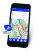
PLAN, DISCOVER, EXPERIENCE - on the web and mobile!
Download our HKF Outdoor App!
Navigator

More than 1000 Web-Sites in 47 countries! Listing of important European Web-Sites supporting your planning and booking of journeys.